Menu
Upper Mustang Trekking
- Day and Nights14D/13N
Overview
Upper Mustang is located in the Dhaulagiri zone at an altitude of 4,000m on the north side of the Annapurna region. The place is geographically a part of the Tibetan plateau, which gives a similar experience while trekking in Tibet. The mustang district was a separate kingdom until 1950 within the boundaries of Nepal. The upper mustang trek takes you to the rare privilege of a semi-independent Tibetan kingdom, which has been settled down for hundreds of years.
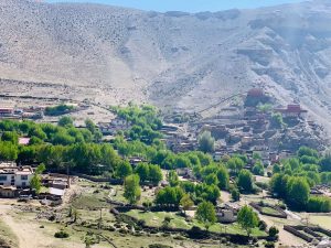
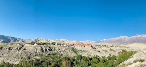
The trek to the upper mustang takes you to an ancient capital city Lo Manthang which is famous for the King's palace. Lo Manthang is a medieval forbidden kingdom that is surrounded by huge walls. You will feel like you have entered into a different world after stepping into the Lo Manthang through the town gate. The Upper Mustang landscape doesn’t possess any green vegetation because of the dry, barren desert. The valley lies in the rain shadow region of the Annapurna region or dessert, which looks so beautiful that the visitor wants to spend hours of hours in the valley. Besides that, the majestic surrounding of the upper mustang treats lots of visitors each year by reminding them of the Grand Canyon of the USA.
People of Mustang follow an ancient form of Buddhism religion which you have never seen around the world. Some of these people of mustang regard themselves as the old descendants of Tibet. The visitors will experience a warm welcome from the Nepali Gurung people along with the Buddhist monk. You can even find the unique richest culture (most likely a Buddhist culture) and traditions of these people who have been preserved in the mountains. You will never know that your heart is already taken away from the kind and friendly people of the mustang. All the houses in mustang are built of white rocks, and wood tucked on the roofs. If you climb to a certain highest place, then you can see those beautiful houses with the prayer flag and the same level of height.
If you are a doctor, then you can also learn an ancient healing art in the amchi (traditional Tibetan doctor) school, which can help you to understand more about the Buddhist tradition. People of mustang also have their own festival called “Tiji,” which is so famous around the mustang region. The festival is celebrated for three days during May every year. You can also participate in the festival to know more about the culture of the Mustang people.
An interesting fact about mustang is that the people of Mustang call themselves Lobas because they settle down the whole community village in mustang without any outside help of people. In the past, the Mustang was a restricted area where foreigners or visitors are not allowed to enter, but in 1992, the policy was unrestricted for outsiders.
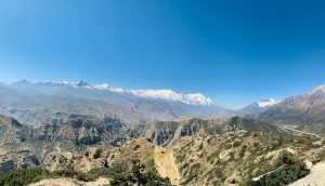
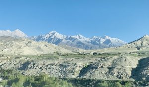
Upper mustang is a famous trekking route that is enriched by stunning mountains, ridges, deep canyons, and moraine valleys. A beautiful unbeaten place of the mustang is unmatched for its impressive, untouched scenery. Furthermore, the journey to upper mustang also provides a fascinating view of Dhaulagiri I (8,167m), Nilgiri (7,061m), Tukuche peak (6,920m), and Annapurna I (8,091m). These entire mountains have clear visibility which pulls out the visitors into their lustful surroundings. Besides that, you can also capture other breathtaking mountains, which are over 6000m high on the trail.
Trek to the mustang is like treasure hunting, where you can explore lots of beautiful places to make a memorable moment. If you love taking photos, then mustang is a more pleasurable place to capture the perfect portrait shot, which helps to cover your photo diary.
Frequently Asked Questions
How Difficult is Upper Mustang Trek?
The difficulty level of the Upper Mustang is moderate, so you don’t have to be extraordinarily physically fit to do the trek on the Upper Mustang. If you can walk for an hour, then you can comfortably explore the Upper Mustang region.
However, taking walks and jogs for a few months before the trek can be beneficial for your body and also helps to boost your stamina level.
And consult your doctor before going on a trek so you can inform your any beforehand medical condition of the local guide or trekking agency. This way, your local guide can help you in case of any physical issues.
Useful Tips for Upper Mustang Trek?
Here are some useful tips while doing the trek on Upper mustang.
- Walk slowly and take a little bit of rest in between walks.
- Drink plenty of water to be hydrated.
- Use the proper windproof gear because the valley is dominated by a strong wind from the north side.
- Use the dressing layer because the temperature of the upper mustang randomly rises and falls according to the altitude level. So you can maintain your clothes according to the weather condition.
- Pack only essential things which can be less difficult and convenient for you to carry.
How About the Altitude Sickness?
Altitude is not an issue while doing the trek on an Upper Mustang because Upper Mustang is at an altitude of 3900m, so don’t worry about altitude sickness. Altitude sickness only occurs in the alleviation of over 4000m; however, precaution is better than cure. So keep an anti-altitude sickness pill such as Diamox, which can be pretty much helpful in case you suffer from altitude sickness.
The team leader also guides you about the necessary steps to take for precaution.
Best Season for the Upper Mustang Trek?
Trekkers can perform the trek to the upper mustang in three different seasons (summer, autumn, and spring).
The summer season (June, July, and August) is more likely to be a favorable time of the year to visit Upper Mustang. At that time, the temperature of the Upper Mustang is mild, with a clear bluish sky and perfect for trekking.
The autumn season (December, January, and February) gives you perfect weather, which is usually dry and cool. The snow-capped mountain gives a breathtaking view of the clear sky during the autumn season. This season is also a peak season, so it’s important to pre-book your trek.
The spring season (March, April, and May) is also the best choice or season for the Upper Mustang trek. The sky will be clear and with lots of newly grown plants and flowers. The temperature is neither too cold nor too hot to do a trek in Upper Mustang. The time is also perfect for trekkers to entertain at the Tiji festival of Upper Mustang, which gives you a lifetime memory.
Tour Booking Form
Itinerary
Fly to Jomsom from Pokhara & walk to kagbeni (4 Hrs/2800 m)
The 18 mints flight is the best mountain flight as it passes through the world's deepest gorge wedged between Annapurna I (8,091 m) and Dhaulagiri I (8,167m). Jomsom is a small town on the base of Nilgiri Himal. We will mostly follow the river bed of Kali Gandaki to Kagbeni. Visit old Kagbeni with 500 years old monastery. Dhaulagiri from Jomsom Flight.
Kagbeni – Chele: (7 Hrs /3050 m- 18 km.)
Today we climb quite steeply up into jumble gullies and small towers, zigzagging to a viewpoint over Kagbeni with Nilgiri providing a dazzling white-fluted back drop from the Kagbeni checkpost. The trail keeps to the east bank of the Kali Gandaki River, climbing and descending. We lunch at Tange village the first village from Kagbeni to meet about 4 hours walk. It is also a Mongolian village where all villagers are a mixture of Gurung, Thakali, and some families from the land of Lo. From Tanbe the trail again climbs to a high point of around 3100 m. The trail then drops steeply and undulates along the east bank of the Kali Gandaki for 1 ½ hours to the village of Chhuksang, from Chhukung we can see the Chele. After a short walk along the river bank, there is a solid bridge across the Kali Gandaki at the point where it tunnels. It's way under a vast block of red sandstone, from here it is a short sharp climb to Chele 3 hours walk after lunch.
Chele – Eklobhatte (6 Hrs/ 3820 m)
The path climbs steeply up to a plateau region through a small tunnel-like gully, climbing more. Gradually, the village of Ghyakar appears to the west as the path rounds a corner. The view South offers a panorama of Nilgiri, Tilicho peak, and Yakawa Kang. The peak that dominates the Thorong La Pass on the Annapurna circuit. To the far east, the range of the Damodar Danda show peaks is visible. From the past, it is a short descent to Samar, a pleasant settlement in a grove of willows with good running water in irrigation channels. We get to Samar village after 3 hours from Chele. It is the lunch place. After leaving Samar the trails dives steeply for about 70 m into a deep side canyon. Inevitably it is a short steep climb out and after a brief respite, it dives again into another side canyon. This second climb is steeper and longer. After about 2 hours walk from Samar, the trail reaches 3750 m and descends slightly to the first tea house. The second tea house can be seen in the distance, but once more the trail dives into another steep canyon and it will take a further hour to reach it. This place is known as EkloBhatte. This is our camping place.
Eklo Bhatte – Ghami (6 Hrs/3520m.)
From camp the trail climbs gently to a small pass at 3870m with views directly below into deeply eroded canyons; which is one of the most beautiful cave monasteries. About 1 1/4 hours from camp, is the tea shop of Syangmochen, another possible camp area. After gentle climb levels out to a Chorten (3700m. 2 hours) and the first view of Geling villages below (3500m). From here the path descends gradually into another less severe valley and climbs out to a collection of houses for lunch after 2 1/2 hours. Gelling would be a good camping spot, with a monastery, Chorten, and fairly extensive flat fields. From the lunch spot, the trail continues round above Gelling and starts the long climb to the Nyi pass at 3950m. A long descent, out of the wind, takes us down more steeply to Ghami 3520m. 11/2 hours from lunch.
Ghami – Tsarang (6 Hrs/3500m-11 km)
From the Gompa in Ghami two tracks level down into a gully east of the village, one steeply past a trio of red, black and white Chortens that are a common sight in upper Mustang. At the bottom of the quilly are two bridges across the river, there is a direct path to this point not visiting Ghami. The trail climbs onto a gently sloping plateau and passes beside a very long mani wall, about 1/2 hour, from Ghami , from the end of the wall, the trail heads east away from a very dramatic red eroded canyon wall towering above the village of Tramar in the distance, climbing steadily an altitude of 3770m is reached after about 2 hours from Ghami. The descent to Tsarang is mostly gentle and completed in a further 2 hours.
Tsarang – Lo-Manthang (5 Hrs/ 3700m. - 13 km)
The trail leaves Tsarang to the northwest and once clear of the village drops steeply into the Tsarang Chu canyon. After crossing the river, the route is initially very steep up a stony track. As we round the corner and head north, a fine view of the great white Himalayan peaks of Nilgiri, Tilicho, and Annapurna I behind Brikuti peak is visible to the southeast, the trail climbs gently along the west side of a side valley to an isolated chorten at 3620 m. 2 hours from Tsarang. A further hour takes us to 3700 m with some spectacular caves high up in the cliffs to the east. Having climbed to around 3850 m. a pass is reached and through a narrow ‘window’ at the Summit the view ahead opens out to display the western valley of Lo-Manthang. The bright red and grey monastery of Namgyal sits on top of a pro monastery, with the wide valley surrounding Tingkat (the site of the King’s Summer palace) and Phewa villages behind Just down from the past is the first dramatic view of the walled city of Lo-Manthang and the ancient ruined forts on the chills behind. There is a tremendous view to the east of the red, blue, grey, white, and yellow eroded Mustang Khola canyon, to the north lie the flattish red-colored hills and the Tibetan border. The western view is dominated by the snow-capped peak of ‘Manaslu‘. The descent to Lo-Manthang is short and after crossing the small river and climbing briefly the fabled city is finally reached.
Lo Manthang and Eastern valleys, Nyphu, Ghaphu 5-6 Hrs round trip.
Lo Manthang and Western valley, Namgyal, Tingkar 4 - 5 Hrs, round trip.
It takes around 2 hours to reach Namgyal Gompa which is situated at the hilltop serves as an important monastery of the local community and as local court. After visiting Namgyal gompa continues the tour to Tingkar, which is the village of around 400 houses, the last main village to the north-west of Lo-Manthang.
Lo-Manthang – Surkhang (3670m) / Yara Gang (Village) 4-5 Hrs.
From Lo-Manthang, the trail walks straight to Dhi pass (4100m) and descends down to Dhi village. Dhi village is one of the best villages in the Lo-Manthang region. It seems more prospectuses and it is settled in a very suitable place. From then on, the trail goes through the river for around 2 hours and then reaches Surkhang.
Surkhang - Lori Gumba (Monastery) – Yara Gang ( 5 Hrs/4000m) and back to Surkhang
Surkhang – Tange Height - (4 Hrs/ 3240 m - 10 km)
From Surkhang, we need to cross a river from Damodar Kunda one of the sacred lakes. There is no bridge on the Ghechang River, so we need to walk across the river in bare feet to cross this river. After crossing the river, the trail climbs up till high above a pass of 3850m, the trail goes through grasslands, a treeless bare hill. After the pass the trail drops directly to Tange village at an elevation of 3240m. Tange is a small village with around 30 houses but most of the houses are attached to each other. On the roofs, one can see the piles of dry wood, which also reflect the prosperity in their society
Tange– Tentang Height (3 Hrs/2940 m Time - 10 km)
The trail walk through the deep ridge of the hill provides fine views of wind-carved hills. Tetang village is formed between 2 hills as they should have found it as a safe place to avoid strong wind that hit the entire Kail Gandaki valley. Tetang is the upper village of Chuksang.
Tentang –Kagbeni
Back to Pokhara on Flight/drive.
Tour Booking Request
What's Included
- Airport transfers
- An experienced insured and equipped English-speaking Guide
- Internal flights and land transport involved in the itinerary
- Accommodation in Nepal with breakfast
- 3 meals during the trek
- Teahouse accommodation on trek twin sharing basic
- Tims permit
- Annapurna Conservation Fee
- Insured and equipped porter as per IPPG rules
What's Not Included
- Travel Insurance
- Nepalese Visa
- Tips for Guide and other trek staff
- Lunch and dinner in the city
- Additional costs due to illness, rescue, force majeure, changes of flight and itinerary
- Personal drinks and Bar Bill.
Add a review