KHOPRA TREK
The Khopra Trek in Nepal’s Annapurna region is a scenic route known for its stunning views of the Annapurna and Dhaulagiri ranges. Typically taking 12 to 14 days, it features charming Gurung villages, lush rhododendron forests, and the breathtaking Khopra Danda viewpoint. Suitable for moderately experienced trekkers, this less-traveled trek offers a blend of natural beauty and cultural experiences, making it a peaceful alternative to busier trails.
Itineraries:
Day 1: Pokhara to Tadapani
Altitude: 2700 meters
Time : 4-5hours
We will drive up to Ghandruk Kimche or further either private jeep or public bus. Then we have to walk most of the part of the walk is uphill. As we take early vehicle we can explore village . Ghandruk is a big Gurung village. There are few gurung cultural museum also. After exploring there we can leave for Tadapani after lunch it goes up. Few parts are steep. Before we reach Tadapani we have to cross one small settlement that is known as Bhaisikharka, means buffalo grazing place. Then we will continue up to Tadapani where our night stay would be.
Day: 02 Tadapani to Dobato
Altitude: 3440
Time:5-6 hours
After breakfast we will start our walk heading north west. We have to walk all the way through the forest. In between there are two places to stop for tea or food. First is called Messar where only tea shop is there after about 3 hours wal . Then an hour earlier from Dobato there is a small settlement called Saru. Specially these houses are made for providing food and accommodation facility for the trekkers. This place called saru is located among the pine forest and peaceful. From here we will continue another hour to Dobato for night stay.
Day: 03 Dobato to Khopra danda
Altitude: 3660 Meters
Time 6-7 hours
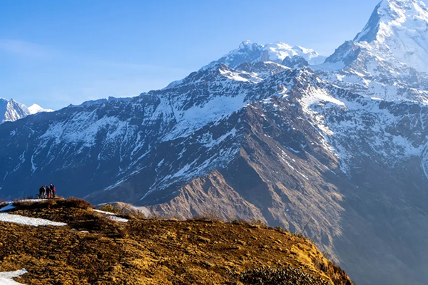
Early in the morning we will go to a viewpoint called Muldai for the panoramic view of Annapurna Dhaulagiri and Fishtail with sunrise. It will take from lodge to view point around 20-30 minutes. After sunrise we will return back to the lodge, have breakfast and continue toward Khopra danda. After about an hours walk we will reach the place called Bayali. From here onward there are two routes high route and low route. If we follow high route path is narrow could be damaged during monsoon.And there is no eating option on high route while walking before we reach Khopra danda.
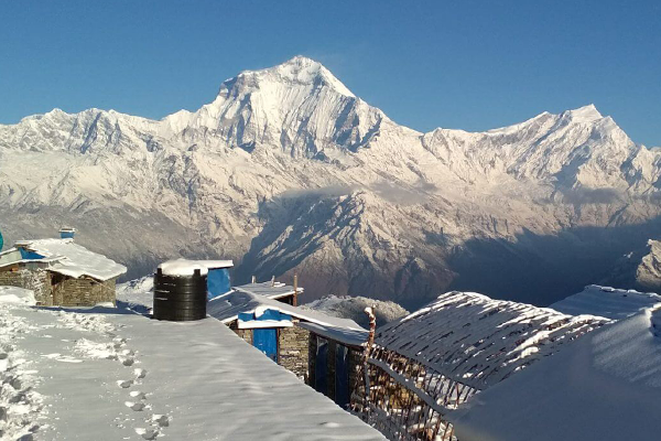
If we have to follow high coute we need to carry pack lunch or little.more snacks for.the day. We have to check as soon as we reach bayali to consult with locals. Other is low route. Which is wider most of the part and have to walk through the forest. It leads first to the place called Chistibang where we can.have lunch. And continue up to Khopra danda. From Chistibang it takes almost 1:30-2 hrs to get to staying place called Khopra danda. Khopra danda is located in such a scenic point. We can see Poonhill on the South west Dhaulagiri and north Baraha peak. There is only one community lodge
where we will find our nest to sleep after long hours of walk.
Day : 04 Day trip to Khayer lake.
Altitude: 4600 meters
Time: 8-9 hours ( both ways)
We will have our early breakfast and head off for Khayer lake grabbing some day lunch and water bottles. Trail goes upward. Time and again we could see the shrines and offered strings of colorful clothes. During july august one festival occurs . Procession goes to worship in the temple of Khayar Barahi. Which is located on the eastern side of this small mountain lake or Tarn. Which is located at 4600 meters. Local people from Myagdi, Paudwar goes to worship. People have a belief that those who do not have children or can not bear the child after worshipping this goddess they will be blessed to have a child. It would be a long day but without big bags. Just day pack with light food and water.
Day :05 Khopra danda to Swanta.
Altitude :2300 meters
Time: 5-6 hrs
After breakfast we will start descending down. Till Chistibang we have to follow the same way down. From here onward also it goes down toward Swanta. All the way we have to walk through the forest. We will be in a settlement side called Swanta. Most of the people are Magar community here. And our night stay would be here in swanta village.
Day: 06 Swanta to Ghorepani
Altitude: 2860 meters
Tim :4-5 hours
As usual, we will leave the lodge after breakfast. First we have to go down to cross a small river through suspension bridge , and it goes upward crossing some houses of Chitre. Ghorepani, was a trading connection during salt trade which used to happen between Tibet and Pokhara. Even the name itself was derived from the connection of the animals they used to use in the past. Horse and donkeys. As they were used as transport they used to be water fed in this place. So was it named. Ghoda means horse and pani means water . This is how it is named. Now a popular touristic place. Because of the Poonhill.
Originally the hilltop which is popular poon hill now used to be called Lungtung danda(hill). Regarding the importance of this hill in order to popularize this hill onee of the local guy was very important. Whose name is Take Bdr. Pun. Who did not have a happy childhood. As his mother elope with someone else and father went taking another wife.
As a stranded child he joined to the Indian army#39;s boys’ service. And continue his education along with army service. And secure a post of Major in Indian army. Whenever he used to return back in the village he used to go to that hill as I mention above lungtung danda. He was so deeply moved by the scenery of the mountains and sunrise or sunset. And had developed a deep interest in promoting this place as attractive touristic place. Accordingly he used to talk with villagers regarding the value of education.and development of the village.
What he have dreamt could not see on his own eyes. Before it came in reality he happen to die mysteriously while celebrating Shivaratri festival. Even after his death his relatives and kins have been taking his dream in mind and have given name Poon Hill to former Lungtug Danda representing whole magar community of Ghorepani. And establish a view tower in his memory. So, now stands a historical Poonhill.
Our night stay would be in Ghorepani.
Day: 07 Ghorepani to Hille
Altitude: 1400 meters.
Time: 5-6 hours
Early in the morning we will walk up to Poonhill it takes about an hour to reach there. Will wait there for sunrise . We can see Gorja peak, 5 Dhaulagiri peaks, Tukuche peak, thapa peak, Mt. Nilgiri, Baraha peak, Annapurna.south, Hiunchuli, Fishtail, annapurna- 2 etc. If the weather favour us. Then, return to lodge have breakfast and continue
down toward Ulleri village another big Magar settlement via Nangethati and Banthati. Will have our lunch in Ulleri and continue down toward Tikhedhunga and to Hille. Where our last night of the trek would be. It is a nice village with terraces.
Day: 08 Hille to Pokhara
Altitude: 830 meters
As usual to the previous days we will have breakfast and leave the place according to our habitual routine of changing places each day. We will walk few minutes to local jeep station. Then catch the jeep either to nayapul or straight way to pokhara negotiating with jeep for cost.